War Games on the Prairie 

From 1963 to 1993, soldiers went underground every day in remote locations around the U.S. not knowing whether this would be the day they would start a nuclear war. 

It was a peacekeeping mission, according to the military. Thousands of miles away, in the Soviet Union, missiles with the same capability of destruction were aimed at cities throughout the U.S.

In many ways, it was the 20th century’s most dangerous game of chess: a constant build-up of weaponry, with each side determined to keep up with the other. A miscalculation on either side could have started the next world war.

These tensions began in the years following World War II, culminating in the Cuban Missile Crisis in 1962. My mother, who was just an elementary student at the time, recalls participating in drills at school in which students crouched under desks to increase their chances of survival during a nuclear attack.

Years later, in the 1980s, I went through similar drills at school, but it was to protect students against falling debris in the event of a tornado or earthquake.

To me, outside of a muscle-bound boxer that gave Rocky Balboa all he could handle, the Soviet Union didn’t seem like much of a threat. It was a just a place that got very, very cold in the winter.

In 1991, after negotiations between the two governments, the U.S. and Russia signed the Strategic Arms Reduction Treaty (START) to reduce and limit their nuclear weapons.

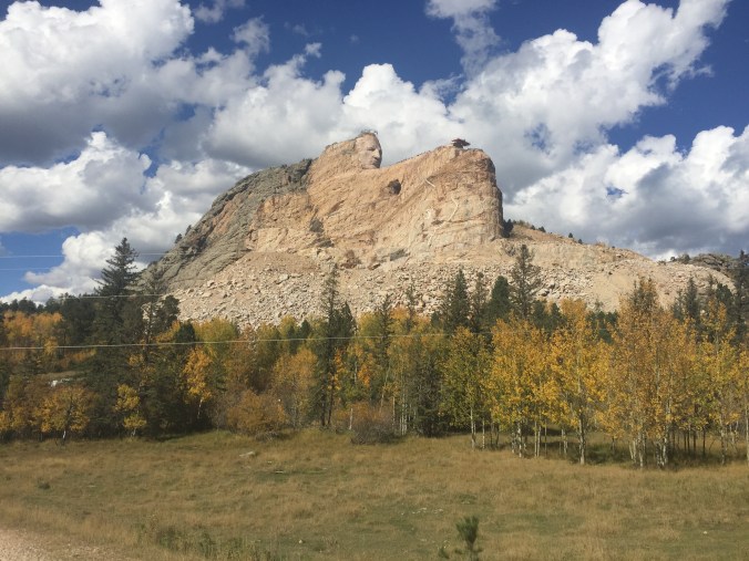
Missile launch control facilities throughout the Great Plains closed, including one in Philip, S.D., about 70 miles east of Rapid City where I live. It was turned into a museum and is now owned by the National Parks Service. For $6, a park ranger will give you a tour of Launch Control Facility Delta-01 Compound.

img_8479

The entrance to Launch Control Facility Delta-01 Compound in Philip, S.D.


Our tour guide, a young man named Ted, met my wife and me at the entrance of the compound, which is still protected by a chain-link fence. Everything was just like the military left it in 1993 when the site closed, down to the typewriters and faded issues of Time Magazine.
We walked past the officer’s sleeping quarters and into a factory-like cage elevator. Ted bolted the door twice — multiple layers of security are commonplace throughout the facility — and we were lowered into a bunker, fortified by concrete thick enough to withstand a nuclear attack.

img_8476

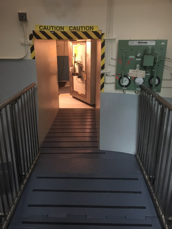
The entrance to the bunker.

img_8478

Two officers stayed in this room 24 hours a day between 1963 and 1993.

img_8471

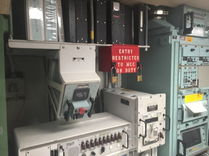
In the event of an attack, the red box would have been unlocked, allowing officers to fire missiles at the Soviet Union.

img_8482

The door to this silo would have blasted off, allowing the missile to fire.

img_8483

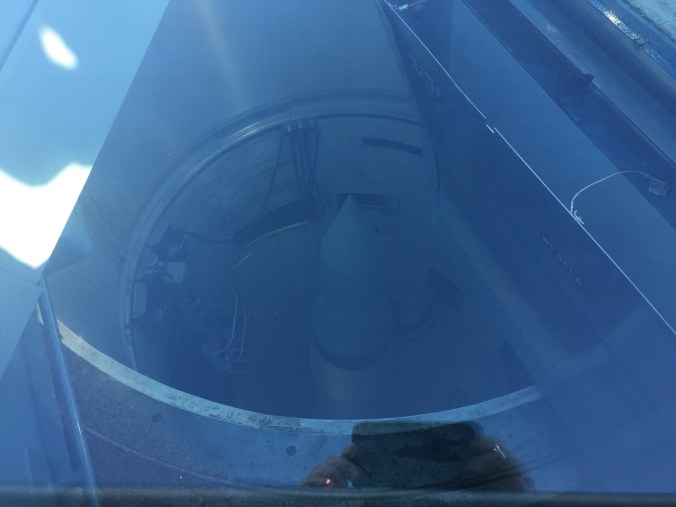
Until the 1990s, the silo contained a fully operational Minuteman Missile.

In the middle of the room, there’s a red box on the wall that reads: ENTRY RESTRICTED TO MCC DUTY. It’s secured by two Master Locks. In the event of an attack, Ted said, two Air Force officers would have opened it simultaneously to launch missiles at targets in the Soviet Union, Eastern Europe and China. 

As the tour came to a close, Ted told us about the handful of times that a miscalculation almost led to war or, using his preferred term, “mutual destruction.” Both sides experienced radar failures during the Cold War that made it appear as if they were under attack, but chose not to fire because they couldn’t be certain.

It was only through extreme restraint, Ted says, that “mutual destruction” was avoided.

As Mount Rushmore turns 75, Crazy Horse memorial still far from complete

One of the world’s most recognizable stone monuments is practically in my backyard. Twenty-three miles southeast of Rapid City lies Mount Rushmore, a national memorial to four of the nation’s presidents: George Washington, Thomas Jefferson, Abraham Lincoln and Theodore Roosevelt.

They are arguably four of the country’s most important presidents. Washington led the successful war effort against the British that gave the United States independence and later served as the nation’s first president. Jefferson was the primary author of the Declaration of Independence and advocated for religious freedom and tolerance. Lincoln guided the Union through some of its darkest and bloodiest days during the Civil War, when the country’s north and south states were anything but united. Roosevelt’s greatest legacy may be the efforts he undertook to protect wildlife and public lands by establishing the United States Forest Service.

These men laid the foundation for the prosperity Americans enjoy today. But for the Native people of this land, that prosperity meant an end to their way of life. Their territory became smaller and smaller, until they were forced to live on reservations established by the government through treaties that were often unfair. The American bison, which many tribes depended on for food, tools and shelter, was nearly hunted to extinction.

There was resistance among Indian nations to U.S. military efforts to expand westward, but as the soldiers’ firearms became more accurate and lethal the battles became more one-sided.

One of those resistors was an Oglala Sioux Chief, Crazy Horse, who defeated George Armstrong Custer’s Seventh Cavalry in June 1876 at the Battle of Little Bighorn in Montana Territory. More than 250 members of the Seventh Calvary were killed in the battle, including Custer.

Following the battle, the military hunted down Crazy Horse, and less than a year later he surrended in Nebraska and was taken to Fort Robinson, where he died after being stabbed during a scuffle with soldiers.

Today, Crazy Horse is memorialized on a stone mountain, just 16 miles west of Mount Rushmore. While the memorial to the presidents was carved in just 14 years, the Crazy Horse memorial, started in 1947, remains a work in progress.

img_0015

Korczak Ziolkowski began working on the Crazy Horse Memorial in 1947.

img_0016

The head alone is 87-feet tall.

img_0014

Once it’s finished, the memorial will become the largest sculpture in the world.

img_0011

Signs near the memorial warn visitors to listen for blasting signals. 

His face is complete, but Crazy Horse’s arm (263 feet wide) and his horse’s head (219 feet tall) have yet to take shape. White paint on the mountainside outlines the spots where construction crews will blast away rock to carve the horse’s head.

Perhaps the main reason the project has taken so long is, unlike Mount Rushmore, the Crazy Horse memorial has received no federal funding and instead relies on donations and revenue from admissions.

I was able to get an up-close look at the memorial last weekend during the biannual Volksmarch, a spring/fall hike that takes visitors more than 6,000 feet above sea level to Crazy Horse’s 87-foot-tall head. It’s one of only two times a year that the public is allowed to hike up to the head.

When viewed from a few feet away, its size is staggering. The chin alone is the size of a basketball goal.

Once it’s finished, the memorial will become the largest sculpture in the world, taller than the presidents’ faces at Mount Rushmore.

But the timetable for completion remains unclear.

Korczak Ziolkowski, who started the sculpture, died in 1982. His wife, Ruth Carolyn Ziolkowski, took over management of construction efforts. Under her watch the memorial became one of the top tourist draws in South Dakota, attracting more than 1 million visitors a year.

Ruth died in 2014, and today her grandchildren and children continue the work that her husband started almost 70 years ago.

In a 2012 interview with the New York Times, Heidi Ziolkowski, one of the couple’s two dozen grandchildren, said she wonders whether she’ll live long enough to see the project finished.

The final work on the Mount Rushmore National Memorial was completed on Oct. 31, 1941, and throughout this year there have been several events to celerate its 75th anniversary.

If you believe Heidi Ziolkowski, who was 24 at the time she was interviewed, it could be half a century or more before the Crazy Horse Memorial celebrates its first.

The Death of Common Sense 

“Aw, look at that 2,000-pound bison. I just want to pinch its foot-long horns and rest my head against its bone-crushing hooves.”

Said no one ever … until recently.

A few visitors to Custer State Park in South Dakota this summer have been injured by the animals after getting too close to them. The tally is four injured, including one person who tried to pet a bison on the head (maybe, under the right lighting, they really do look like they’re just dying to be cuddled).

These are the first such incidents in five years at Custer State Park, which is home to around 1,300 bison. 

“The safest place to watch them is from your car,” a park employee told the Rapid City Journal in July.

That should be obvious, but we live in a time when motorists drive off demolished bridges and plunge to their deaths because Google Maps says to go straight; when hikers, in pursuit of a selfie that’ll rack up likers on Instagram, pose at the edge of cliff and fall off; and when teens walk into oncoming traffic because they’re chasing imaginary Nintendo characters on their cellphones.

That said, it’s not a stretch to assume that some visitors to Custer State Park aren’t paying attention to the signs that read: BUFFALO CAN BE DANGEROUS. DO NOT APPROACH.

The park employee, being polite, said an uptick in visitors could be to blame. 

I beg to differ and cite a different reason: Common sense, like the American bison in the 1800s, could be on the brink of extinction.  

The ‘crown jewel’ of Custer State Park

One of the first places I was told to visit after moving to Rapid City was Sylvan Lake.

It took a few months, but I finally made it there over the weekend. This majestic body of water, located high in the Black Hills and about 45 miles southwest of Rapid City, is considered the “crown jewel” of Custer State Park.

It’s easy to see why: I had planned on jogging the one-mile loop trail that takes you around the lake, but instead walked at a leisurely pace to admire the tall rock formations that sit at the edge of the water.

A word of wisdom to first-time visitors: Bring a hat or wear sunscreen. The lake sits at an elevation of 6,145 feet and the sun is intense, even in the cooler months of the year.

IMG_7086

A devil of a hike

“How much farther do we have to go?” a young boy asked, as he passed me with his family while I descended from Little Devils Tower, elevation 6,908 feet.

“Is it like 35 feet?”

“Thirty-five plus a couple of zeros,” I responded.

His dad chucked, but the kid didn’t get my joke. “You still have a ways to go,” I told him.

Perhaps it was the elevation. Perhaps my lungs are still recovering from five years in Beijing, which at times felt like living in a smoking lounge. Perhaps I’m just out of shape.

The Black Hills, in southwestern South Dakota, is full of beautiful rock formations.

The trail to Little Devils Towers is around 3 miles out and back.

People come from all over the world to rock climb in the Black Hills.

Whatever the reason, I had to stop several times to catch my breath along the winding and rocky path to the summit of Little Devils Tower, one of the highest peaks in the Black Hills. The occasional breaks allowed me to take in the magnificent giant rock formations, which jut into the sky from the mountaintop.

The name of the place, Little Devils Tower, is misleading because there’s really nothing little about it. At nearly 7,000 feet, it’s one of the highest points in the United States east of the Rocky Mountains.

On a clear day, it is said you can see more than 100 miles out onto the horizon from the highest peaks in the Black Hills.

Little Devils Tower is located in Custer State State Park.

The skies were mostly clear when I visited. From the summit, you can see the spot where the hilly terrain ends and the high plains begin.

The last leg of the journey to the top is the most difficult. The dirt trail gives way to rocks and boulders, and I had to pause a few times to figure out the best way to climb over them safely. A series of blue markers posted on tree trunks and rocks help you stay on the path, but it’s easy to get sidetracked if you’re not paying attention.

A view from the summit, elevation nearly 7,000 feet.

From the trailhead, I was able to reach the summit within a couple of hours. It’s an easy hike to finish in an afternoon, unless, of course, you’ve got a kid in tow who asks “Are we there yet?” every 35 feet.